ILEX Computing - Survey, Certification & Geodetic Solutions
Strategic Software for the Offshore Survey, Geophysical, Marine, Diving, Construction and Renewables Industries
QC CalcGIS - Pack of Offline Geodetic and Acoustic Survey Utilities
Geodetic Conversions
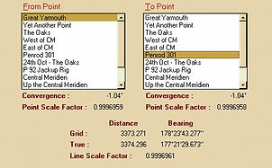
There are several Geodetic utilities to perform coordinate conversions, datum shift and range/bearing computation. Determine a 3 parameters datum shift from a known point. Compute convergence, scale factor and plot coordinates on charts using GIS or CAD background layers.


Acoustic Operations Utilities
USBL and Network adjustment routines are provided to compute correction factors and provide QC for USBL data provided by contractors. Network adjustment facility to compute errors and adjustments in a multi-base/transponder array to provide best fit solutions and error statistics.
Both are backed up by Velocity of Sound profile entry, computation using different formulae to suit conditions.


Planning & Quality Control
Use the various routines to plan or QC a project, coordinates can be saved and overplotted as lines or points on a background chart. The chart can import GIS layers such as .SHP and also .DXF, .DGN and GeoTIF files to allow data to be displayed in different formats and coordinate systems.
A serial GPS interface is provided so that a defined vessel shape can be shown on the display.
A Catenary calulator is included to allow marine operators to compute touchdown distances or clearances of mooring lines for barges, semi-sub rigs or FPSOs.


